On the Road
Aside from the time many decades ago when I crossed the border at Tijuana with a girlfriend and her toddler, trying to keep her VW bus alive, made it down to the beach at Ensenada where I bought one of those handwoven and popular-at-the-time hooded pullovers from which I got lice—aside from that brief adventure, tomorrow will be the first time I’ve driven in Mexico.
We’re renting a 2005 Chevy compact from a guy up in Ixtlahuacan who’s having it delivered to our doorstep—$200 a week, all insurance included. It might have dents, he said, but it’s guaranteed to run well. A Brit by the sound of his voice.
 |
| I've rehearsed this particular interchange many times. We come into Ocotlan on Hwy 35, about 75 km from home, cross the river and look for an overpass, moving into the right lane. The sign will say "MEXICO [as in City] Cuota". We take a quarter cloverleaf onto the overpass and Hwy 6, trying to stay on that road through the busy town, near where, six weeks ago, federales killed 20 some reputed narcotraficantes...Yikes! |
I’m driving some number of kilometers that are supposed to consume about 4 hours over mostly pretty good roads to a village in Michoacan everyone raves about. Here in Mexico there are toll roads called cuotas that are better than Oklahoma’s Turner Turnpike last time I was on it; of course, that was almost 20 years ago. About 2/3 of the way to Patzcuaro, we’ll be on a cuota.
From recent experience as a passenger on several trips around Jalisco I know that it’s when you’re trying to find a connecting road that the trouble usually starts. The directional signs always say some city or road that you’ve never heard of, may not even be on a map. So you take your chances, most likely roll snake eyes and stop for directions from some nice señor drinking beer with his buddies about to climb into the back of a pickup.
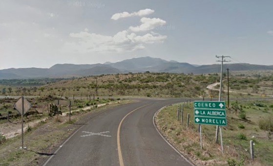 |
| The damn sign should direct us left to Cerritos, not to the tiny village of La Alberca (which translates as "Swimming Pool" referring to a nearby round-shaped pond), and it's totally wrong for Morelia. |
He doesn’t want to disappoint you by saying he has no idea what you’re talking about so he speaks that rapid Spanish you hate but you don’t want to disappoint him and ask for him to speak un poco mas despacio—a little slower. He consults his compadres, yammers and waves and points and you hear a few numbers and maybe a left or a right. You repeat this dialog two or three or more times on down the highway and finally you stumble upon what you think is the right road. And if you’ve lived the good life, it is.
I’d rather not go through all that on this trip even though who knows what serendipitous happening we might be missing.
 |
| Our Destination! We're staring in Hotel Refugio de Angel, right near Plaza number 9. |
To forestall that experience I’ve been spending a lot of time on Goggle maps, zooming in way close to see exactly where that turnoff is, exactly how many kilometers it is from the last turnoff, and exactly how many kilometers it is to the next. I’ll be shit out of luck if this Chevy Corsa’s odometer runs in miles and not metric.
I took screenshots of the salient interchanges. That information in hand, still on Google maps, I clicked on Street View and virtually traveled down each stretch of dusty road until I saw the sign that announced my turnoff. And took another screenshot of that. Good thing, too, because, there were some towns on the signs that I wouldn’t have expected. I mean, instead of a bigger town at the end of a stretch of road, why does the sign instead give the name of a much smaller pueblo halfway there?
That’s the kind of question that gringos around here always answer with an affectionate shake of the head, “Because it’s Mexico”. Wish us luck.
No comments:
Post a Comment